Notch Pass
Olympic PeninsulaBest Apr–Nov
A steep CCC-era trading route climbs through deep Olympic forest to a pass visible from Highway 101.
About This Trail
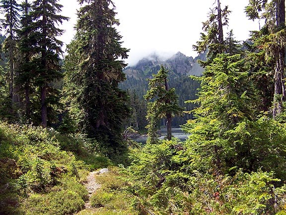
The Notch Pass trail follows a historic route through the Quilcene Range, once used as a Native American trading path and later rebuilt by the Civilian Conservation Corps in the 1930s. The trail climbs steeply through mossy hemlock and red cedar forest on constant switchbacks, gaining 2,000 feet over 2.1 miles to reach the notch visible from Highway 101. Small creek crossings punctuate the ascent.
Beyond the pass, the trail drops 300 feet over 0.7 miles, crosses Forest Road 100, then continues 1.5 miles to the Lower Big Quilcene Trail junction. The forest canopy keeps the route shaded and cool even on warm days. Trip reports consistently note quiet conditions with few other hikers on trail.
The access road (Road 010) has rough spots and water-filled potholes but remains passable for most vehicles. WTA volunteer crews maintain the trail regularly, with recent work focused on rebenching tread and improving drainage. A bridge featured in older trail photos has collapsed due to rot.
Forecast
Astronomy
Trail Conditions
“Road to the trailhead was rough in places with some very wide, water-filled potholes, but no problem navigating with a mid-size SUV.”
Last report: May 5, 2026
Scorecard
Safety & Considerations
Today's Hazard
- Strong sun — sunscreen, hat, and sunglasses recommended; water reflection adds glare near the lake
Persistent Hazards
- Collapsed bridge along route
- Rough access road with water-filled potholes
Getting There
No pass required. The lower trailhead off Road 010 has limited parking. The access road is part paved, part gravel with potholes that are passable in a standard vehicle but easier in a higher-clearance SUV.
Two trailhead options. The lower trailhead starts from Penny Creek Road via Road 010 (1.4 miles of rough road). The upper trailhead uses Forest Road 27 (Big Quilcene Road) for about 7.5 miles. Most hikers start from the lower (east) trailhead for the full out-and-back experience.
No timing pressure. The trail sees very few other hikers regardless of start time. A morning start allows time to explore the full route to the Big Quilcene junction and back.
Recent Reports
This is a GREAT "workout" trail. From Notch 1 TH you climb steadily to the pass, cross a little used FS road, then take Notch 2 down-ish to the FS NF-27 road, then down Notch 3 from NF-27 to the Lower Big Quil trail.
Beautiful early season out-and-back hike over Notch Pass to Big Quilcene and Bark Shanty. Gorgeous green everywhere, and the trail is a pleasure to walk.
Beautiful day to hike and first time hiking on the peninsula... so gorgeous.
Similar Hikes