Mildred Lakes
Olympic PeninsulaBest Jul–Sep
An unmaintained scramble through dense Olympic forest to alpine lakes in the Mount Skokomish Wilderness.
About This Trail
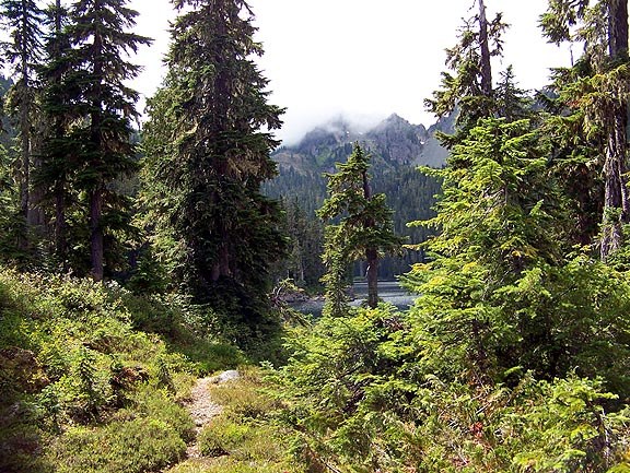
This is not a standard trail. The route to Mildred Lakes follows an informal path beaten into the forest by decades of hikers and anglers. Beyond the first mile at Huckleberry Creek, the way turns steep, brushy, and difficult to follow. Expect to lose the route, pick through blowdowns, and climb over root tangles. High-top boots with ankle support are strongly recommended. Map and compass skills are necessary.
The lakes sit in a rugged basin surrounded by the peaks of the Mount Skokomish Wilderness. The largest lake offers swimming in summer, though the bugs at the lakes are notoriously aggressive from June through August. Permethrin-treated clothing helps. Some hikers use this as an approach for Mount Lincoln.
The access road follows Forest Service Road 25 along the Hamma Hamma corridor for 14 miles, with the first 8 paved. Note: as of August 2025, this trail is closed due to the Bear Gulch Fire. Check current status before planning a trip.
Astronomy
Trail Conditions
Scorecard
Safety & Considerations
Persistent Hazards
- Unmaintained route: expect blowdowns, lost trail, and route-finding challenges
- Aggressive biting insects at the lakes June through August
- Steep, slippery terrain with root tangles and loose footing
- Bear Gulch Fire closure: trail closed as of August 2025, check current status!
- Bear country
Getting There
Small trailhead area off Forest Service Road 25. Northwest Forest Pass required. No facilities at the trailhead.
From Hoodsport, drive north on Highway 101 for 14 miles to Forest Service Road 25 (Hamma Hamma Recreation Area). Follow FS Road 25 for 14 miles to the trailhead. First 8 miles are paved, remainder is gravel. The route itself requires strong navigation skills and prior experience with unmaintained trails.
Start early. The route takes 6-10 hours round trip depending on conditions and route-finding speed. Not a place to be caught in the dark without a headlamp and GPS.
Similar Hikes


