Lower South Fork Skokomish River
Olympic PeninsulaBest Mar–Nov
An old-growth river valley walk through giant firs with Roosevelt elk, creek crossings, and a waterfall turnaround.
About This Trail
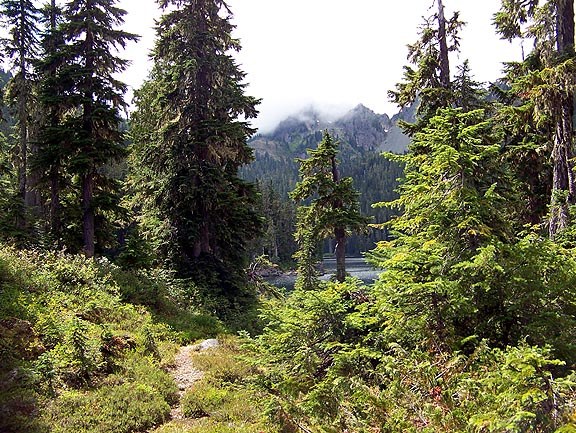
The Lower South Fork Skokomish River trail follows an old-growth valley deep into Olympic National Forest. Massive Douglas firs hundreds of years old line the route, mixed with maple, alder, and hemlock as the forest transitions through different zones. The river runs alongside for much of the distance, providing a constant soundtrack.
The trail starts with switchbacks through sword fern and salal before settling into a riverside grade with gentle ups and downs. At roughly 6.5 kilometers, a bridge crosses above a waterfall near the old Camp Comfort site, marking a natural turnaround for day hikers. Beyond that point the trail continues another 10 kilometers to the Upper South Fork trailhead, though conditions deteriorate past the 14 km mark.
Roosevelt elk frequent this valley. Sightings are common enough that trip reports mention them regularly. The access road (FR-2353) is paved and open to all vehicles despite what Google Maps sometimes claims. The trail surface varies: gravel, boardwalks, rock, and mud all appear in sequence, with creek crossings adding variety. Northwest Forest Pass required at the trailhead.
Astronomy
Trail Conditions
Scorecard
Safety & Considerations
Persistent Hazards
- Roosevelt elk frequent the valley
- Creek crossings may require wading after heavy rain
- Trail deteriorates past 14 km mark
Getting There
Northwest Forest Pass required. Parking at the trailhead off FR-2353. The road is paved and suitable for all vehicles despite occasional incorrect Google Maps closure notices. Upper and lower parking areas available.
From Shelton, take Skokomish Valley Road 5.5 miles to FR-23. Continue 9 miles to FR-2353, turn right over the river, then left at a four-way junction to reach the trailhead. Road is paved the entire way.
The waterfall and bridge at 6.5 km make a good turnaround point for a moderate day. Allow 4 to 5 hours for the full out-and-back. Early starts help for the longer version but the trail sees light traffic regardless.
Similar Hikes