Duckabush River
Olympic PeninsulaBest Mar–Nov
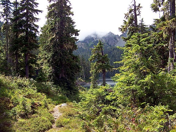
Old-growth forest and blue-green river water on a long valley trail leading deep into the Olympic wilderness.
About This Trail
The Duckabush River Trail climbs through thick moss-covered forest of bigleaf maple, old-growth cedar, and Douglas fir. The river runs a distinctive blue-green, visible from several points along the trail. At about 2.5 miles, the path passes through a grove of massive cedars in a quiet, shaded glen. The trail then gains elevation through a series of switchbacks up Big Hump, where Snack Rock provides a viewpoint overlooking the river valley and surrounding peaks.
Past Big Hump, the trail drops steeply to Fivemile Camp at roughly 5 miles in, losing about 650 feet of the elevation just gained. This makes the return trip more demanding than it first appears. The 2011 Duckabush Fire left standing snags in portions of the upper trail, and winter storms regularly drop trees across the path. WTA crews clear blowdowns annually, but expect to navigate over or around downed trees, particularly early in the season.
The trail continues deeper into the Olympic wilderness for backpackers, connecting to a broader network of river valley routes. Day hikers commonly turn around at Snack Rock or Fivemile Camp. The trailhead sits at the end of a 6-mile road that transitions from pavement to gravel, with some rough sections in the final stretch.
Astronomy
Trail Conditions
Scorecard
Safety & Considerations
Today's Hazard
- Strong sun — sunscreen, hat, and sunglasses recommended; water reflection adds glare near the lake
Persistent Hazards
- Seasonal blowdowns, particularly in the fire-affected zone
- Big Hump is a significant climb with steep switchbacks
- Rough access road in the final 2.4 miles
- Return trip regains 650 feet lost descending to Fivemile Camp
Getting There
Trailhead lot holds about 20 vehicles. Northwest Forest Pass required. Arrive by 9am on weekends for reliable parking. Collins Campground is 1 mile before the trailhead.
From Quilcene, drive south on Highway 101 for 15 miles. Turn west at the Duckabush Recreation Area sign. Continue 6 miles on the access road (pavement ends at 3.6 miles). Pass Collins Campground at 5 miles. Beyond the horse parking area, turn right onto Forest Road 2510-060 to the trailhead.
Morning starts work best. Allow 5-7 hours for a round trip to Fivemile Camp. The Big Hump climb hits hardest on the return. Snack Rock at roughly 3.4 miles makes a good shorter turnaround.
Similar Hikes