Yacolt Burn State Forest - Bells Mountain
Southwest WashingtonBest Apr–Oct
A long forest traverse from Moulton Falls through the Yacolt Burn, climbing over its namesake summit and linking into the Chinook Trail network.
About This Trail
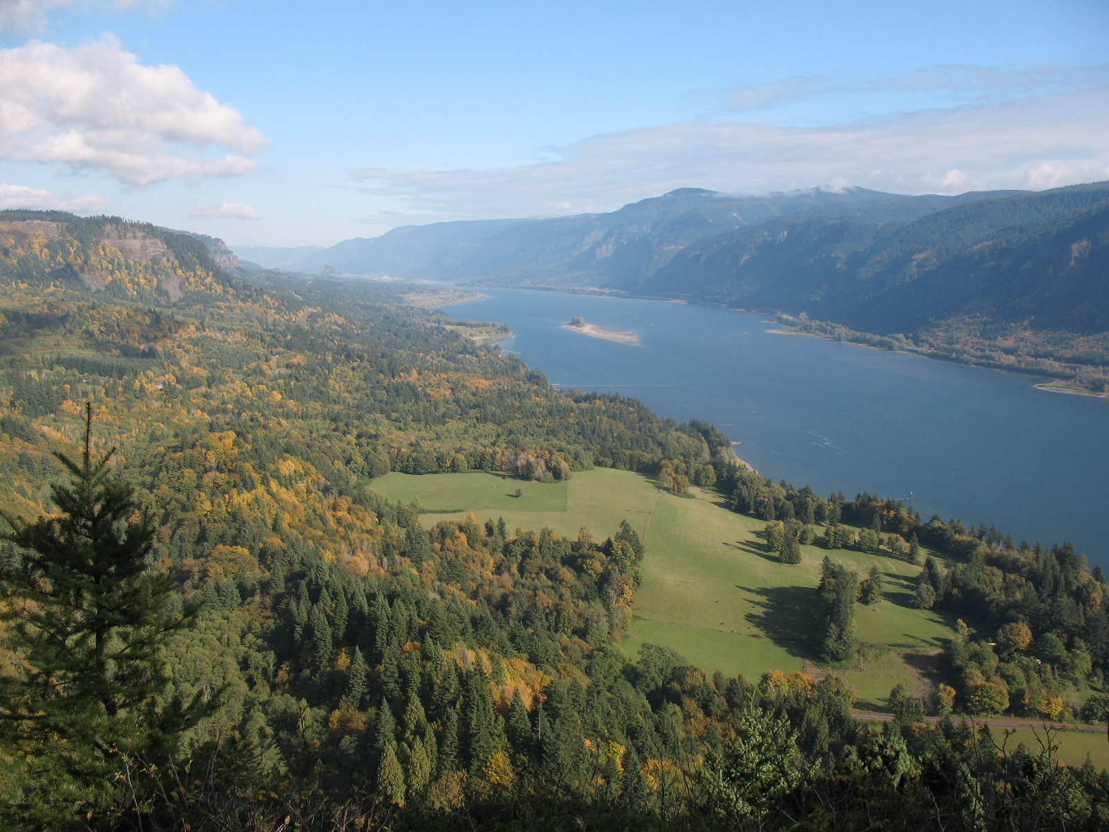
Bells Mountain is the northernmost section of the Chinook Trail through the Yacolt Burn State Forest, running 8.9 miles one-way from Moulton Falls Regional Park south to the Yacolt Burn Trailhead. The first mile climbs steadily through alder and Douglas-fir stands up and over Bells Mountain itself, then the route rolls south through a patchwork of recovering forest, clearcuts, and creek crossings.
The northern trailhead at Moulton Falls is the real draw for most folks. Free parking, a popular park with a beautiful arched bridge, and the Lewis River right there. From the overflow lot, walk the paved path to the signed trailhead just west of Bridge 120. The climb up Bells Mountain rewards with views of the surrounding ridges and the Lewis River valley.
Be aware that the middle section of this trail passes through actively managed timberland. Some hikers report water-filled tire ruts from illegal ORV use, and clearcut areas offer little shade. The trail is part of the Chinook Trail Association's 30-mile National Recreation Trail (designated 2005), connecting north to Moulton Falls and south to Cold Creek Campground and eventually the Tarbell Trail loop. Trail maintenance has been consistent, with WTA work parties out every year since 2022.
Astronomy
Trail Conditions
“All felled trees off trail, brushed, bridges in good shape.”
Last report: Feb 12, 2026
Scorecard
Safety & Considerations
Today's Hazard
- Strong sun — sunscreen, hat, and sunglasses recommended; water reflection adds glare near the lake
Persistent Hazards
- Illegal ORV activity on middle sections
- Exposed clearcut areas with no shade
- Trail can be muddy and rutted
Getting There
Park at the Moulton Falls Regional Park overflow lot for the north end. Parking is free, no pass required. For the south end, use the Yacolt Burn Trailhead off Dole Valley Road.
From Moulton Falls overflow parking, walk the paved path to Bridge 120. The trailhead is signed just west of the bridge. Head south, climbing steadily for the first mile up Bells Mountain. At 7.1 miles you pass Cold Creek Campground; the route ends 1.5 miles further at the Yacolt Burn Trailhead. Most day hikers do a shorter out-and-back from Moulton Falls.
Start early for the full point-to-point traverse. A car shuttle or bike stash at the far end saves the long walk back. For a shorter day, the first few miles from Moulton Falls make a good out-and-back.
Recent Reports
Did the logging trail. All gravel road 2.
Well maintained, and recently. All felled trees off trail, brushed, bridges in good shape.
You have to park at the overflow parking for Moulton Falls Regional Park, can confirm that parking is free and you don't have to pay anything or have anything prior to parking! You walk down a paved path until there's a couple signs that directs you to start going down a trail that goes up, and then there's a lot of different routes you can go if you want to actually get to the top of Bell's Mountain.
Similar Hikes