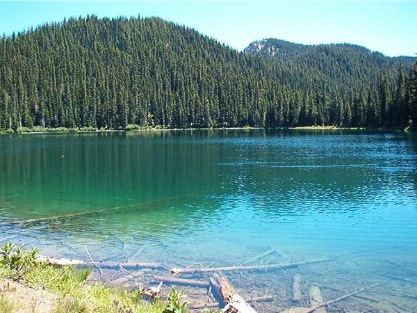
Pear Lake
Central CascadesBest Jul–Sep
Quiet alpine lake below Fortune Mountain, reached through burn zones and old forest along the PCT.
About This Trail
Pear Lake sits in a high basin below Fortune Mountain at the boundary of the Henry M. Jackson and Glacier Peak Wildernesses. The approach follows the Top Lake Trail through a mix of old forest and the 2014 Shoofly Fire burn zone before joining a short section of the Pacific Crest Trail. The burn opened up views that were not there before, and on clear days you can see Glacier Peak from the trail.
The lake itself is a compact alpine gem ringed by meadow and subalpine forest, good for swimming in August, and surrounded by blueberry bushes that ripen in late summer. Black bears are regular visitors to the Lake Creek drainage, drawn by the same berries, so proper food storage is essential. Campsites are established around the lake and along the approach.
Getting here requires some commitment. The drive to the trailhead involves navigating a series of forest roads off North Shore Road near Lake Wenatchee, and the final spur (FR 6701-500) can be rough. The trail itself is not technically difficult, but downed trees have been a persistent issue, and the route receives less maintenance than more popular destinations. Trip reports consistently flag blowdowns, so bring patience and route-finding sense. This is a place that rewards people willing to work for their solitude.
Astronomy
Trail Conditions
“When I saw the road is impassable a mile before the trailhead I changed my plans and did this.”
Last report: Aug 1, 2025
Scorecard
Safety & Considerations
Today's Hazard
- Strong sun — sunscreen, hat, and sunglasses recommended; water reflection adds glare near the lake
Persistent Hazards
- frequent blowdowns across trail
- rough forest road access
- black bears in Lake Creek drainage
- limited trail maintenance
Getting There
Trailhead at end of FR 6701-500, signed for Top Lake. Access via Lake Wenatchee area: Highway 207 to North Shore Road, then FR 65 to FR 67 to FR 6701. Final spur road can be rough. Northwest Forest Pass required. No toilet at trailhead.
Follow the Top Lake Trail through forest and Shoofly burn zone. Trail joins the PCT briefly before dropping to Pear Lake. Route passes Top Lake along the way. Persistent blowdown issues have been reported from 2021 through 2025. Be prepared to navigate around or over large downed trees.
Start early for a day hike. The approach roads take time to navigate, and 13 miles round trip with 2,200 feet of gain makes for a full day. Backpackers have more flexibility.
Recent Reports
Our first time doing a "key exchange" hike, and it was so fun! We parked at the North Fork Skykomish trailhead off FS 63; our friends parked at the Smithbrook trailhead just east of Stevens Pass.
Day 1: Smithbrook Trailhead to Lake Janus Day 2: Day hike from Lake Janus to Lake Valhalla and back Day 3: Lake Janus north on the PCT to Washington Pass Day 4: Washington Pass to Fortune Ponds via Pear Lake Day 5: Fortune Ponds to the Meadow Creek trailhead 28. 2 miles hiked (by the map; probably more because of a few side trips) ~ 4,000 foot total elevation gain My hiking partner and I met up in Monroe early Monday morning, bought our forest passes at the Skykomish ranger station, and drove to
I headed here to car camp and clip out the Tenas Creek Road beyond the end, which I started last Fall. When I saw the road is impassable a mile before the trailhead I changed my plans and did this.
Similar Hikes


