Mount Stuart
Central CascadesBest Jul–Sep
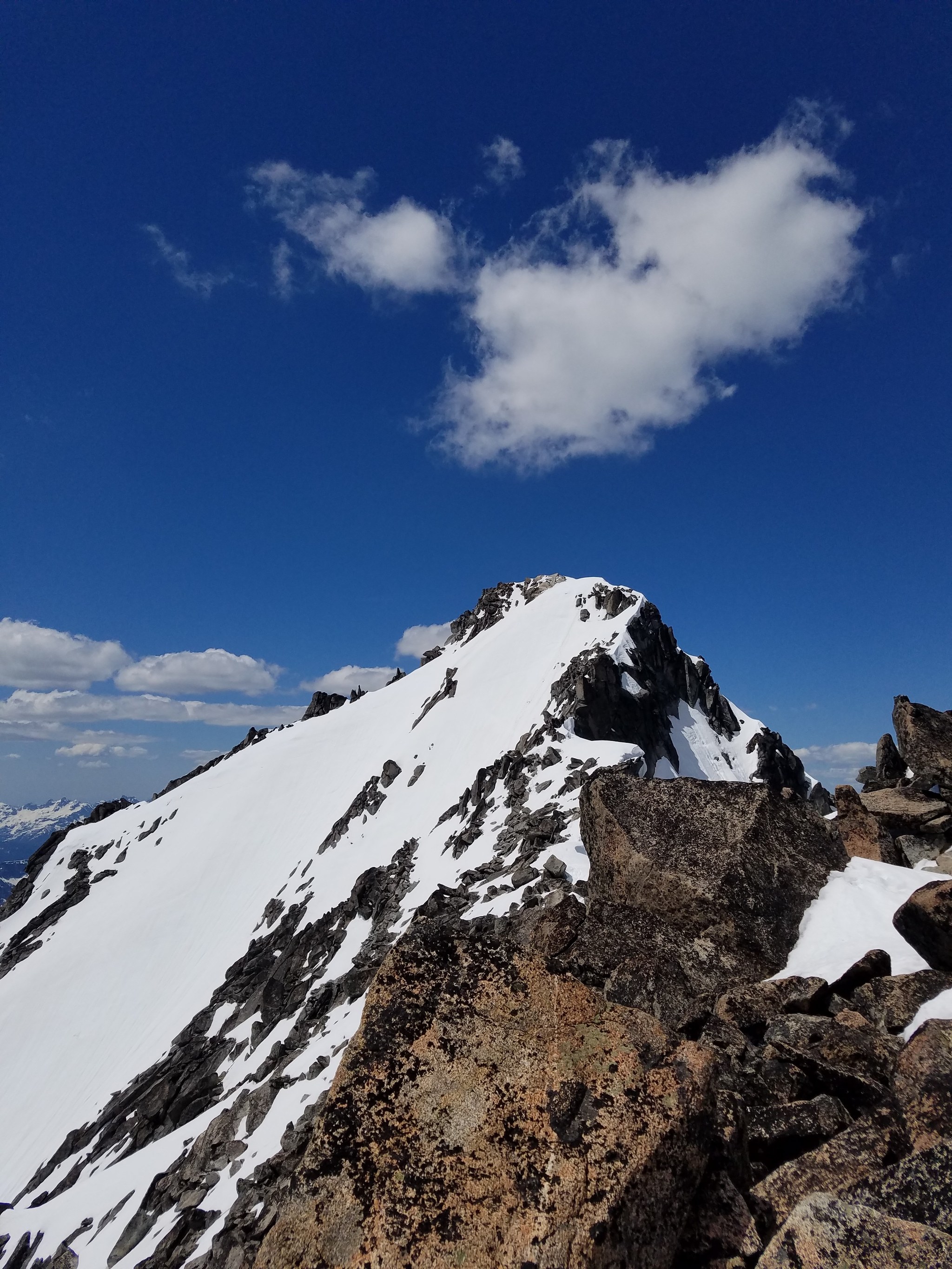
Washington's second-highest non-volcanic peak at 2,870 meters, a serious scramble up the Cascadian Couloir with 360-degree views of the entire Cascades spine.
About This Trail
Mount Stuart rises to 2,870 meters, making it the second-highest non-volcanic peak in Washington behind Bonanza Peak. The standard route via the Cascadian Couloir covers 17.9 km round trip with 1,923 meters of elevation gain. This is a major mountain objective that demands fitness, scrambling ability, and solid route-finding skills.
The approach crosses Longs Pass and drops into the Ingalls Creek drainage before climbing steeply into the couloir. The Cascadian Couloir itself is a Class 3 scramble on variable rock and scree, with conditions changing significantly depending on snowpack and season. Early season brings consolidated snow that can simplify the couloir but requires ice axe and crampons. Late season exposes loose rock and scree that makes every step deliberate.
The summit block delivers one of the finest viewpoints in the state. Mount Rainier, Mount Adams, Glacier Peak, and the full Stuart Range spread out in every direction. The Enchantment lakes glitter directly to the northeast. On clear days, the view extends to the Olympics.
Most parties camp at Ingalls Creek the night before and push for the summit at first light. A single-day car-to-car push is possible for very fit scramblers but leaves little margin for error. The mountain demands respect: weather changes fast at nearly 3,000 meters, and retreat from the couloir in deteriorating conditions requires careful downclimbing.
Astronomy
Trail Conditions
“Hiked up/over Longs Pass Saturday afternoon, camped at Ingells Creek that night.”
Last report: Aug 29, 2025
Scorecard
Safety & Considerations
Today's Hazard
- Strong sun — sunscreen, hat, and sunglasses recommended
Persistent Hazards
- Class 3 scrambling with significant exposure
- Loose rock and scree in the Cascadian Couloir
- Rapid weather changes at 2870m
- Route-finding in the couloir
- Snow and ice early season requiring axe and crampons
Getting There
Esmeralda Basin / Longs Pass trailhead off Teanaway Road. No pass required. The trailhead road is rough but passable for most vehicles. Limited parking at the trailhead.
From Cle Elum, take SR 970 east to Teanaway Road, then follow North Fork Teanaway Road to the end. Cross Longs Pass (2,072m) and descend to Ingalls Creek before ascending the Cascadian Couloir on Stuart's west face. Cairns mark portions of the route but expect route-finding through talus and the couloir.
Camp at Ingalls Creek the night before for a summit push at first light. Single-day attempts require a 3-4 AM start and 14-18 hours of continuous movement. Do not start late.
Recent Reports
Route taken: Cascadian couloir Distance (RT): 12. 0mi/19.
Hiked cascadian couloir as an overnight. Hiked up/over Longs Pass Saturday afternoon, camped at Ingells Creek that night.
Climbed Mount Stuart one day push. Camped at trailhead night before and began hiking around 5 am.
Similar Hikes


