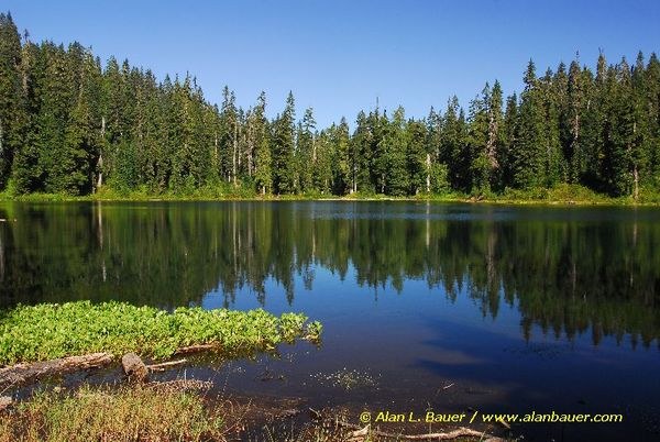
Evans Lake
Central CascadesBest Jul–Oct
A short walk through old-growth forest to a quiet 11-acre alpine lake in the Alpine Lakes Wilderness, where the drive takes longer than the hike.
About This Trail
Evans Lake sits at 1,128 meters in the Alpine Lakes Wilderness, reached by a nearly flat half-mile trail through old-growth hemlock, Douglas fir, and silver fir. The walk takes about 15 minutes each way. The real effort goes into getting there: a long drive up Forest Service roads that demands high clearance and patience.
The lake spans 11 acres with a forested shoreline. Two campsites sit near the inlet stream, and campfires are allowed here, which is unusual for the Alpine Lakes Wilderness. An overgrown boot path partially circles the lake, though downed trees make the loop rough going. Huckleberries ripen along the shore in late summer.
The unsigned trailhead can be hard to spot. Look for a pullout area on the left side of the road with a rocky trail heading uphill on the right. Road conditions are the primary concern; multiple trip reports flag rough, brushy Forest Service roads. A Northwest Forest Pass and self-issued wilderness permit are required.
Forecast
Astronomy
Trail Conditions
“A long drive up on forest service roads to get to the turn around across from the trail head.”
Last report: Aug 12, 2025
Scorecard
Safety & Considerations
Today's Hazard
- Strong sun — sunscreen, hat, and sunglasses recommended
Persistent Hazards
- rough forest service road - high clearance recommended
- unsigned trailhead
- downed trees on lake loop path
Getting There
Small pullout area at the unsigned trailhead. No signs visible from the road. Northwest Forest Pass required.
From Monroe, take US 2 east to mile marker 50.5 (just east of Skykomish Ranger Station). Turn south onto Foss River Road (FS 68), stay right at the FS 6835 junction, continue 3.5 miles, then turn left onto FS 6846 for 2 miles. Trailhead is on the right. High clearance recommended. The drive up the forest roads takes much longer than the hike itself.
No timing pressure given the short distance. The long drive is the main time commitment.
Recent Reports
Super easy and short trail through lush bushes and forest. A long drive up on forest service roads to get to the turn around across from the trail head.
Trailhead was hard to find, there were no signs visible from the road. There is a pullout area to your left and to your right you will see a rocky trail going up.
Just a shout out to whoever lugged two metal canoes up to the lake. Unfortunately one of the canoes is totaled, looks like it fell victim to a falling tree and is flatten.
Similar Hikes


